 Raindrops.
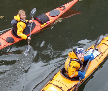
 Kayaker and cut, Wrangell Island.
 Sunny respite from raindrops: all the gear is out to dry.
 Our summer solstice campsite.
 Another cut reminds us that we are closing in on the city and borough of Wrangell, Alaska. Raindrops. Kayaker and cut, Wrangell Island.Sunny respite from raindrops: all the gear is out to dry. Our summer solstice campsite.Another cut reminds us that we are closing in on the city and borough of Wrangell, Alaska.
 This rock was so alluring we decided to live here. Or at least to live here during lunch.

 Beckoned by the grey: here we peel off from Deer Island and aim for Zimovia, between Etolin and Wrangell Islands.
 North of Meyers Chuck we encountered mysterious orange ocean-haze. We asked each other, what is a red tide? Is this a red tide? The orange got on our kayaks, our paddles, our boots, the shoreline, everything. Needless to say, we ate no shellfish.
 Some of the slowest paddling possible took place on this piece of water. Innocent though it looks, it is possesed by a siren-like countercurrent that nearly held us at a stand-still. The island in the background is also touched: even at this distance the air was still shaking with the grunts and barking and groaning burps of sea lions hauled out on the granite.
 A spritely tide whisked us in and among these islets which dot the shore of Deer Island. It was a welcome change from the invisible current bogging us down a few days earlier.
 This is how a clearcut looks after it has had time to green up. Even though the greenery makes for a bit of a jungle right now, trees of uniform height will grow and will eventually block the sun from reaching the understory. Little vegetation of any nutritional value to deer, for example, will survive. Decades from now, when this patch looks again like a forest to those of us out on the water, wildlife will still be forced to avoid the area.
  Southeast Exposure's big red barn from which kayak tours are guided. We had the luck to be welcomed to Ketchikan by the folks running this operation. Their hospitality kept us safely out of trouble while preparing food and gear for the next leg of the trip.
  Two boats, two damp and chilly paddlers, and one blue tarp beneath which to celebrate a joyful crossing of Behm Canal.
  A most fantastic food hang on the Cleveland Peninsula by Mr. Behnke. The sand on this beach bore the marks of plate-sized bear tracks criss-crossed with a floral pattern of deer prints.
  The last sky we slept under before discovering Meyers Chuck, a bit of an eerie fairytale envisioned, built, and inhabited by a handful of backcountry homemakers.


 Post-nap: Christopher and his devil's club halo.
 Corinna and the beloved New Zealand Macpac tent.
 An eerie visit to the privately-owned Bell Island Hot Springs: this place was so recently abandoned that although buildings and boats are in shambles, books remain on the shelves and clothes hang in the guest house closets. The pipe system has fallen to pieces, so the hot springs no longer even feed into the pool.
 Christopher passing the teardrop islands of Naha Bay.
 We open with sunlight in Ketchikan (soon diminishing to rain) and an itch to leave town. We here point southeast.
 Christopher and New Eddystone Rock set the stage for Misty Fjords.
 Walker Bay and severe clear.
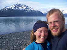
 Christopher, Corinna, and our Revilla circumnavigation mascot, Captain S. Foster.
 Ralph, our retired atomic physicist and provider of all things seafoody, hands Scott a camera. Soon thereafter Ralph hands off three lively dungeoness crabs which scramble about in the hulls of our boats until supper.
